
Geographical and Geological Introduction of Barendra Region or Rajshahi Division
Location: Barendra region or the present Rajshahi Division is located between 23-48'-30" North latitude and 26-38' North latitude and 88-02" East longitude and 89-57' East longitude. The Tropic of Cancer passes slightly south of this point (between 24 and 23 degrees north latitude). 90 degrees is located exactly in the middle of the Eastern Hemisphere, so it is located between 88 degrees 2' and 89 degrees-57' longitude and is located almost in the middle of the Eastern Hemisphere.
Boundaries: Purnia, Jalpaiguri and Cooch Behar districts of India to the north, Purnia of India, South and North Dinajpur districts of India and Malda district to the south, Murshidabad and Nadia districts of India across the Padma River and Kushtia and Rajbari districts of Bangladesh and Dhubri district of India to the east. India's Tara district located across the Brahmaputra river and Jamalpur and Tangail districts of Bangladesh located across the Yamuna river.
Area and Population: The area of Barendrabhumi i.e. Rajshahi Division comprising the five districts of Greater Dinajpur, Rangpur, and Bogra, Pabna and Rajshahi is 13,369 square miles (34,654 sq km) and according to the 1981 census, its population is 2,18,96,891. And the number of people per square meter is 1637 people.
Varendra Multipurpose Development Authority is an organization under the control of the Ministry of Agriculture.
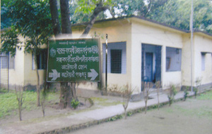
Barendra Multipurpose Development Authority, Atwari Zone Office Head Designation-
Assistant Engineer
Brief description of office activities:
Barendra Multipurpose Development Authority has carried out activities such as crop production through irrigation, construction of rural connectivity roads, afforestation to bring natural balance, re-excavation of canals and ponds for surface water conservation and provision of arsenic-free clean drinking water by constructing overhead tanks adjacent to deep tube wells for irrigation.


Planning and Implementation: Cabinet Division, A2I, BCC, DoICT and BASIS
Technical Assistance:
![]()
